
 |
| Tenerife - Day 2 |
Day 2 began with a long and tedious drive to Santa Cruz in search of the elusive Mount Teide permit. I duly followed the elaborate instructions posted here, however when I'd finally found the underground car park and the Office Parc Nacional de Teide tucked away on the 4th floor in a deserted block of offices the whole scam had been a hoax and there is no such office, or at least it is permanently closed and the only way to get the permit is via the internet, but there were no internet cafes in Santa Cruz.
The only other way to get to the summit without a permit, apart from the method I eventually chose, is ostensibly to stay at the Altavista Refugio at 3260 metres, however of course when I phoned the refugio there was no response.
The only solution I was left with was to stuff the lot of them and just run up the hill anyway.
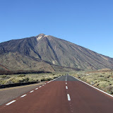
It was just after mid-day when I finally reached the foot of the hill and set off. There was no space to park at the trailhead, so I abandoned the car about 600 metres up the road in a viewing point. I then ran back and all the way the Montana Blanca trail past the Huevos del Teide, giant egg-shaped lumps of lava.
At 2700 metres the angle suddenly becomes much steeper to the Refugio at 3260m. I could see why nobody had answered my phonecalls since the whole place was shuttered up.
It was now easier angled and more runnable again, but at over 3,000 metres I was slightly nervous about conking out with lack of oxygen.
Things became more interesting just before the top cablecar station. For one thing the trail was suddenly crowded with tourists shuffling along the path and getting in the way, and for another I spotted the dreaded rangers post, where a tiny metal gate was barring the route to the summit. I quickly turned around, hoping not to have been seen, and to plot my next move. I back-tracked around 50 metres until just out of sight of the rangers, and then with a deep breath I battered across some rough scree to jump back on the main path above the rangers. My shortcut was only around 100 metres, but meant for a minute or so I was at risk of being spotted and cautioned.
At first I was out of sight of the rangers hut, but the ensuing barrage of shouts and whistles made me suspect they must have spotted me. I jumped back onto the path, ignoring their attempts at attracting my attention and walked as quickly as possible up the path to the summit. For the final few metres there was an overwhelming stench of sulphur making me feel slightly ill, not helped by the altitude and stress of how I was going to get down again.
I slowly walked back down the path, but the rangers were too lazy to come up and give me any grief. I wasn't that keen to have to repeat my shortcut, but after sitting and contemplating my move for around 5 minutes I decided I had no option, so as soon as the rangers looked distracted I snuck across the scree, keeping a low profile, and once on the main path casually merged back in with the tourists.
The adrenaline rush gave me a fast descent back to the car with a good 1200 metres drop.
It was a relief to get the big Mount T in the bag, and once relaxing at the Parador Visitor Centre cafe I realised that nothing else on the island would live up to this outing, so I started to plan an early return home.


No comments:
Post a Comment