Thursday 27 November 2014

British & Irish Masters Cross Country

22nd November 2014 - Wollaton Park, Nottingham

Results | Track on Strava

This was my 3rd time representing Scotland at the British & Irish Masters. Previous efforts were Dublin 2010 and Bellahouston, Glasgow 2011.  So this was my first time in the Over 50s race.

Friday was quite tiring with an epic coach journey down to Nottingham from Glasgow, arriving in the dark and pouring rain.  I checked into the Travelodge before heading out in the dark and rain to track down food and drink with several Clydesdale runners.

I had already started going down with the lurgy mid-week and woke in the night feeling grim with sore throat, so wasn't confident about the race.

The Scotland team convened at Wollaton park at 10am for pre-race photos.

Scotland Team Photo

My race started at 12:30pm

Start of M50-64 race

With 4 laps of a 2km course, I set out at conservative pace. After 300 metres, I'd passed all the Scottish runners except Stan Mackenzie and Peter Buchanan. I had to hold back a fraction to avoid passing any more runners, and settled in behind Peter. After maybe 500 metres, I passed Peter, and then focussed on closing the gap to Stan.  The gap didn't change much for the first 2 laps, and at the start of the 3rd lap I briefly passed Stan going up the hill, but he passed me straight back going down the other side.  After that I just plugged away, trying to hold position, whilst leaving something for a strong finish.  I did get passed by one Northern Irish runner, but don't remember too many other going by.

Chasing Stan Mackenzie (Peter Buchanan behind)

Strong finish
The 4-lap course at Wollaton Park:

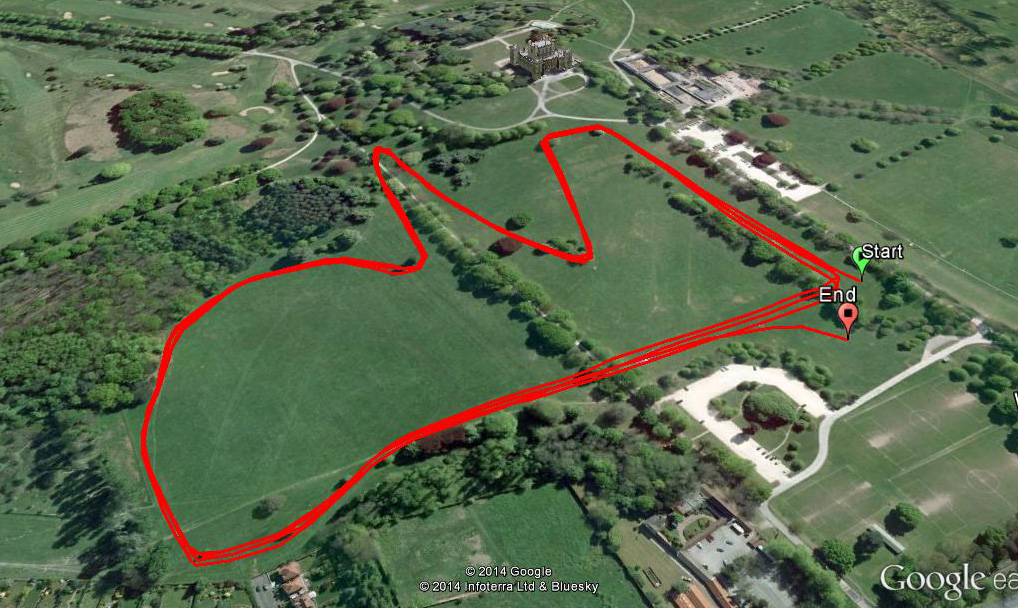
The end result was I finished 2nd in the Scottish Team, 11th M50 overall, and we picked up Bronze team prize, the team being Stan, me, Peter and Ted Gourley.

Saturday 25 October 2014

Scottish National XC Relays

Results | Photos

My first time representing Ronhill Cambuslang at the National Cross Country Relays.  The weather was largely dry with the odd blustery shower passing through.

I was running in the V50 team along with Paul Thompson and Colin Feechan.  Paul went off first and came in well up the field.  I went out steady, and found myself running with Marc McColl and Paul Carroll.  I thought I would be able to hang onto them both, but somehow let them both slip away. The only runner to come past after the opening tussle with Marc and Paul was Graeme Murdoch of Gala who seemed to make up a huge number of places. I thought I'd run reasonably hard enough to give us a good chance of team gold.  Colin gave it his best shot on Leg 3, running 1 second faster than me in 15:40, but it wasn't enough to stop Andy Little of Shettleston snatching the lead in the final 800 metres or so.  We therefore had to make do with team silver.

Approaching the end of Leg 2. Photo: Bobby Gavin
Cambuslang M50 Team Silver

Cambuslang M50 Team Silver
Battling in the wind on Leg 2

Sunday 28 September 2014

Swiss Alpine Pass Route

An 11-day hike across Switzerland via the so-called Alpine Pass route, or Via Alpina (marked as National Route #1).  The hike started at Sargans near Liechtenstein, and finished at St Gingolph by Lake Geneva.  Link to online map
Roughly 360km with 21,500 metres of ascent.

Photo albums:
Day 1 | Day 2 | Day 3 | Day 4 | Day 5 | Day 6 | Day 7 | Day 8 | Day 9 | Day 10 | Day 11


View Alpine Pass Route in a larger map

Day 1 - Sargans to Weisstannen (Sat 6th Sept)   Photos from Day 1 
2h10m, 14km, 640 metres ascent
The trip started at 5am in Glasgow with a train and bus to Edinburgh Airport. Then an Easyjet flight to Geneva, and 3 trains to Sargans, via Biel and Zurich. So it was after 5pm before I started hiking. I faffed around a bit leaving the train station at Sargans, trying to decide to whether to buy any food, but decided on balance it was better to get a move on since I was pressed for daylight hours. I reached Hotel Gemse after 2 hours, just as the light was starting to fade. I was in a shared dorm, but nobody else was staying. Dinner was schweineschnitzel, beer and chips, accompanied by traditional folk music.

Leaving Sargans on Day 1
Approaching Weisstannen on Day 1

Day 2 - Weisstannen to Martinsmad-Hütte (Sun 7th Sept)   Photos from Day 2
6h58m, 30km, 2193 metres ascent
I set off at 8:25am just as the locals were heading to church. The trail was wooded and cool with heavily dewed grass. Gradually the trail climbed above the treeline to the Foopass at 2223m, the first major pass of the route. On the descent I stopped for a while at a small farmstead to eat bread and cheese, and chat with some local hunters and cheese-makers (blessed are the cheese-makers), before battering down a long stony track towards Elm. Just before reaching Elm, I decided to head steeply back uphill again to the Swiss Alpine Club Martinsmad-Hütte at 2002m. It was a good sociable evening chatting with Swiss hikers, who were all doing short multi-day hikes in the region.
Foopass 2223m
Martinsmad Hutte 2002m
Day 3 - Martinsmad-Hütte to Klausenpass Hotel (Mon 8th Sept)   Photos from Day 3
12h27m, 45km, 3055 metres ascent
7:10am start with a steep descent to Elm. A quick snack at the village bakery in Elm, then upwards and onwards towards the Richetlipass. The pass has a false col then flattens out before the real pass at 2261m.  The descent entered some slightly wilder country, and a short sharp rain storm added to the effect.  Once down in Linthal I re-grouped for a few minutes, then decided to head for the Klausenpass, having read that the Klausenpass Hotel is "unmissable". I summited the Klausenpass just as it was getting dark, only to discover the hotel is still another 2km down the other side. Schweineschnitzel, beer and chips again for dinner, although I was too exhausted to finish the beer.  The night was creepily quiet in the bunkhouse on the opposite side of the road.

Richetlipass 2261m

Approaching Klausenpass

Klausenpass Hotel
Day 4 - Klausenpass Hotel to Spannort Hutte (Tue 9th Sept)   Photos from Day 4
11h02m, 42km, 2506 metres ascent
After a leisurely breakfast in the Klausenpass Hotel, I was away just before 8am. The route fiddled around below Schachentaler Windgallen before dropping into the Schachental valley.  Unfortunately I was day-dreaming so ended up in Unterschachen and had to hike along the road to Spiringen. There was quite a bit more hiking down the road to get to the outskirts of Altdorf. I missed out going to the town centre to see the famous statue of William Tell, but instead headed straight across to Attinghausen for the steep slog up to Brusti.  I had thought of staying the night in Brusti, but instead decided to press on over the Surenenpass 2291m.  The weather got iffy on the descent.  Misty. Pouring with rain. Full waterproofs required. I got a bit confused in the mist, but eventually found a sign pointing upward to the Spannort Hut. It was getting pretty late by this stage, and the climb to hut was steep and rocky. I arrived just as it was getting dark.  The guardian was surprised to have a visitor.  Nobody had visited the hut for several days. It was a very quiet night, with just the sound of rain and running water outside.
Sunrise at Klausenpass (Schärhorn)
Surenenpass 2291m
Approaching Spannort Hutte (Titlis)
Day 5 - Spannort Hutte to Meiringen (Wed 10th Sept)   Photos from Day 5
11h43m, 45km, 1864 metres ascent
Misty, murky weather leaving the Spannort Hutte. Mass migration of cattle, bringing them down for the winter, as I dropped into the Surenen valley. A long gradual descent to Engelberg, then quick supermarket stop before heading back uphill towards the Jochpass.

The Swiss have an uncanny knack of converting their wonderful natural landscapes into industrial building sites, and the Jochpass was no exception with an enormous new hotel in mid-construction. I headed on past various lakes to the Tannensee at which point the weather really closed in. One minute it was quite tolerable, and the next I was scrambling for full waterproofs and getting a real pelting from the rain and wind.  The route headed along an undulating ridge to Planplatten 2245m on the edge of a ski area. It really was pretty grim, and I was glad when the trail finally started descending towards Meiringen.  It took a fair old while to descend the 1650m to reach the "Sherlock Holmes" town of Meiringen, and then I had to try a few hotels before finally getting a very quiet room at the Hotel Rebstock.

Trübsee before the Jochpass 
Descending to Meiringen after the storm
Day 6 - Meiringen to Lauterbrunnen (Thu 11th Sept)   Photos from Day 6
10h13m, 42km, 2477 metres ascent
Another fairly cloudy overcast day.  Pretty cool dull weather all the way to the Grosse Scheidegg 1962m, which I hadn't appreciated has a road up it from both sides, so not exactly a wilderness experience. The view from the pass must be stunning on a clear day, but we had to make do with fleeting glimpses of the Eiger. The descent to Grindelwald was pleasant enough, with great views of the Wetterhorn, Schreckhorn and Lauteraarhorn taking me back to 1997 when I climbed the Wetterhorn with Jeff Knight and Micky Ross.

Entering Grindelwald was awful after solo-hiking for several days. Far too many people, and commercialisation gone mad. I stopped to grab food from the Coop, then kept walking without stopping for a break. The trail to Kleine Scheidegg couldn't have been more straightfoward. A steady trail of tourists. It does feel bizarre when you reach the col, and the Swiss have built a major railway station, with hordes of people, and cigarette smoke blowing in your face. Needless to stay, I kept on hiking straight over the other side and down towards Wengen and Lauterbrunnen.  It was quite late, and getting dark when I reached Lauterbrunnen, but I found a room at the Hotel Schutzen right beside the very spectacular Staubbach Falls.

Hotel Rosenlaui 
The Eiger from Grosse Scheidegg
Wetterhorn above Grindelwald
Day 7 - Lauterbrunnen to Griesalp (Fri 12th Sept)   Photos from Day 7
7h02m, 28km, 1866 metres ascent
The day dawned with torrential rain in Lauterbrunnen. I faffed around getting waterproofs on, by which time the rain had more or less stopped.  It was still pretty damp and cool for the hike up to Murren.  For a while on the hike to the Rotstock Hut the weather threatened to improve with the odd fleeting of a snowy peak. I stopped at the hut for a bowl of soup, and chat with an American guy from San Francisco, and then ventured out into the increasingly cold and grey conditions for the climb to the Sefinenfurgge 2612m.  The rain was turning into sleet, and the descent was on black shale for a while. Lower down it started raining properly for the hike out to Griesalp. I checked into the Naturfreundehaus Gorneren, which turned out to be a good evening chatting with an American guy Damon, and Swiss guy Chris over dinner and a few beers.

Staubbach Falls at Lauterbrunnen

Gspaltenhorn above Mürren
Day 8 - Griesalp to Adelboden (Sat 13th Sept)   Photos from Day 8
11h08m, 36km, 2671 metres ascent
An early 6:45am start for the climb to the impressive Hohtürli Pass 2778m, the highest point on the Alpine Pass Route. For once, the weather didn't disappointment. Great views of snowy peaks, with wispy low-lying clouds. I pottered down the other side the outstandingly scenic Oeschinensee, then continued down to Kandersteg for a supermarket stop. After eating as much as I could in 10 minutes, I headed up to the surprisingly dramatic Bunderchrinde 2385m, and impressive rocky gash reminiscent of the Breche de Rolande. The hike out to Adelboden had an uphill sting in the tail. It was not the kind of place to find cheap accommodation, so I checked into the Hotel Waldhaus Huldi at the end of the main street.

Hohtürli Pass 2778m

Hohtürli Pass 2778m

Oeschinensee above Kandersteg
Day 9 - Adelboden to Gsteig (Sun 14th Sept)   Photos from Day 9
9h20m, 36km, 1984 metres ascent
A leisurely breakfast at the Waldhaus Huldi then an easy hike over the Hahnenpass 1956m to Lenk. Everything was shut in Lenk, apart from a bakery with virtually nothing left, so I just kept on hiking, for once in pretty hot and sunny conditions. I crossed the Truttlisberg Pass 2038m to Launen, then kept going straight over the Krinnen Pass 1659m to Gsteig, where I checked into the Hotel Bären which had an incredible chilled-out atmosphere, with great music in the bar restaurant.

Descending towards Lenk

Hotel Bären at Gsteig
Day 10 - Gsteig to Col des Mosses (Mon 15th Sept)   Photos from Day 10
6h31m, 23km, 1366 metres ascent
Today marked the transition back into French-speaking Switzerland after crossing the Blattipass 1900m. After the Col des Anderets 2034m the trail fiddled around contouring for a while before reaching some chalets at Chersaule, where I took a break to sit out of the sun and relax for a few minutes. It was quite hot and oppressive when I reached Col des Mosses a short while later. It was early afternoon, but there was no point in continuing today, so I checked into the Hôtel Le Relais Alpin and watched a re-run of yesterday's Vuelta final time-trial in my room.
Arnensee after the Blattipass
Col des Mosses in pouring rain
Day 11 - Col des Mosses to St Gingolph (Tue 16th Sept)   Photos from Day 11
8h45m, 35km, 816 metres ascent
The final day. A gentle descent to Lac de l'Hongrin past some sort of Swiss Army training camp. Around the lake some huge barrages, then through a tunnel, and down a road to a scruffy farm at Vuichaude d'en Bas.  Some nice autumnal colours on the hike up to Col de Chaude1621m, when Lac Léman (Lake Geneva) opens out below. The 1200m descent lead down to the vineyards above the historic town of Villeneuve.  I took a break for a while looking out across Lake Geneva, before hiking around the lake through the Grangette Nature Reserve and over the Rhone to reach St Gingolph on the French border, and where I started the GR5 hike to the Mediterranean 2 years ago.

Leaving Col des Mosses

Lac de l'Hongrin

Approaching Col de Chaude

Col de Chaude

Lake Geneva at Villeneuve
Looking back to Col de Chaude from edge of Villeneuve

Grand Canal at Les Grangettes

Lake Geneva at Le Bouveret
Lake Geneva from St Gingolph

Sunday 31 August 2014

Paisley 10k

Results | Garmin track

My 5th 10k race in just over 2 weeks after Bella Belter (36:18), SVHC Glasgow 800 (36:57), Irvine Marymass (36:13) and Bute Highland Games (36:12).

My 2 targets today were to dip under 36 minutes, and if possible to get 1st V50.

I'd not run the Paisley 10k before, but the weather was perfect. Bright and sunny, and not too warm.  Plus it was nice to be running on closed off streets for much of the route.

I realised as soon as I arrived that my main V50 rival would be Alex Robertson of Motherwell.  Given that Alex had been completely out of sight at the Calderglen 10k and Bella Belter, I wasn't sure how I'd get on with keeping him within sight this time.

The start was all pretty frantic with a high quality field leading out, so the first km was quick-ish, but not too mad.  I got drawn into passing Alex a couple of times early on, which I suspected was not a great idea.

By 2km I'd dropped back from directly chasing Alex and George Pettit.


I went through the 5k marker on 17:45, which I thought meant sub 36-min was on the cards.

James Healy caught me around 7km, so we worked together on the disused railway.

I could see Alex and Andrew MacKenzie almost within catching distance just ahead.

As we crossed Canal Street with 1km to go I realised we were on 32:36, which meant a sub 3:24 final kilometre to break 36 minutes.  I gave it more or less all I had, and closed down Alex to within 5 seconds, but finished in 36:06.  Still it felt like another good steady 10k, without exerting myself too much.

Paisley 10k route


Monday 7 July 2014

800 races (of sorts)

Here's a full list of my 800 races, as of 5th July 2014.

It all started back on 14th May 2000. A lone figure approaching along the Ben Dronaig track like Omar Sharif in that haunting scene from Lawrence of Arabia.

With tension rising, and wondering whether to stop for a chat, I realised I'd bumped into this chap on Cairnkinna Hill about 6 months previously. He was one of those elite hardy folk known as "fell runners" who do things called "fell races".  At that time I had absolutely no idea how you would go about entering a fell race, but this seemed like a good time to pick Eddie Dealtry's brains for top tips on where to start.

So, I came away with a short-list of Borrowdale, Glen Rosa and Jura as good entry-level hill races.

Jura was in 2 weeks time, but race organiser Andy Curtis quite rightly wouldn't let me race without previous experience.  I therefore begged Paul Emsley to allow me a run at Glen Rosa 3 weeks later. I finished 5th last out of a field of 32 runners with only one male runner behind me: the legendary Drew Turnbull. My back was in agony the whole way round, and I missed the turning below the deer fence coming off Goatfell at the end, and got lost in the woods above Brodick Castle at the end, but at least I'd finished the race and left plenty of room for improvement.

So, fast forward 14 years, and I've just completed my 800th race (of sorts) at Glasgow Victoria Parkrun on 5th July 2014.  I've used the term "race" loosely to include club handicaps, grudge matches, time trials, etc., as well as officially organised events.

Events have ranged from Scottish National Indoor 1500m track race at Glasgow Emirates Stadium (shortest and highest number of officials), to 10-stage high altitude Everest Sky Race in Nepal (longest, highest and worst organised).

Possibly the most enjoyable was the Defi de l'Oisans 200km stage race in France, which I've completed 4 times (2004 to 2007). 6 fantastic scenic stages around the Ecrins Massif on the GR54, starting and finishing at Les Deux Alpes.

Defi de l'Oisans

I've run London Marathon 7 times, and Ben Nevis 8 times, as well as completing the Two Breweries and Pentland Skyline the past 12 years in a row.

Ben Nevis Race

I've completed more than 330 different race routes or courses, and have raced in England, Scotland, Wales, Northern Ireland, Republic of Ireland, Isle of Man, France, Corsica, Slovenia and Nepal.

So, having not been sure how to enter a race in 2000, I'm quite pleased to have managed to complete a variety of races now over most distances and terrains from indoor track to the horrors of Glamaig.

Scottish Hill Racing races

Power of 10 races

Sedbergh Hills

Monday 28 April 2014

Glasgow Miler Meet - Scottish 10,000m Championships

Photos by Bobby Gavin | Activity on Strava | Results

My first attempt at racing on a 400m track.  I was slightly daunted by be running in the "B" Race, since I could immediately see I was the slowest runner.  I was also nervous about the idea of trying to run fast, since I haven't run fast in any races this year, still not fully trusting my hamstrings.

Anyhow, the weather was pretty appalling. Cold, wind and raining. So it was a bit grim hanging around watching the "C" Race. I was actually glad not to be running in the "C" Race, since this gave me more time to get ready, and I'd rather be chasing from the back, than leading from the front.

Once we stepped onto the track, nobody seemed to know the protocol of how the race started, or where the start line was, but we were soon on our way, with Mark Pollard pace-making at 33 minutes, which equates to about 79 seconds per lap.

I just about hung on for the first lap before slipping off the back, chasing after Iain Burns of Bellahouston RR.  For several laps I thought I might catch Iain, until the gap became too big to close.  For the next few laps, it was just a question of waiting until I was lapped.  It wasn't until my 10th lap that Mark Pollard and Barney Phillips came past.

At the halfway point I glanced at my watch to see 17:53, so was thinking at this point that sub 36 minutes would be close.  I tried to keep pressing all the way, and it was helpful when Shaun Butler went by, so I could latch onto him for a while.

Before I knew it, we were down to 8 laps (2 miles), then 4 laps (1 mile), and then the bell and the final lap. For the last 200 metres, I was the only runner left on the track, so made the most of it to finish in 35:55.

It was also my first outing in the new club colours of Ronhill Cambuslang.

Glasgow Miler Meet - Hutchesons' Grammar School

Sunday 9 March 2014

Balloch to Clydebank Half Marathon

Activity on Strava

This was my 6th Balloch to Clydebank Half Marathon.

Previous times were 1:18:17 (2007), 1:20:04 (2008), 1:19:30 (2009), 1:18:15 (2011), 1:19:54 (2012).
So I'd only once gone over 1:20, and that was by 4 seconds in 2008.
Anyhow, given that I've hardly run at all since the hamstring injury at Christmas, I had no intention of racing today, so this was purely an experiment to see if I could run 13 miles at even pace without my hamstring packing in.  I almost got away with it, but for some reason suddenly felt really washed out after 10 miles, and the last 3 miles were tougher than I'd expected.

Photo: Gillian Scott
www.scottsportphotography.co.uk

Sunday 26 January 2014

Devil's Burdens Relay

Results | Strava track | Garmin track

I haven't blogged in ages, mainly because I haven't done any running in ages.

Thankfully I managed my first successful run of the year at the Devil's Burdens Relay yesterday. This was my first run since 27th December when I bust my right hamstring at the Lancaster Festive 4km, and limped off the route.

I was feeling slightly apprehensive on the startline at Falkland, wondering if my hamstring would be OK, and duly started off super-slowly not wishing to shock-load my leg at all. Anyhow, I plodded along waiting for some twinges or ill effects, but nothing much happened, so I gradually pressed on passing Tess Hill, another runner, then I ran alongside Craig Mitchell for a while, before Ewan Jack caught us both. I tried hold position with Ewan, but he was that bit stronger, and I didn't want to force anything, so just ran as relaxed as I could.

Just before entering the finishing field, it was good to see James Callender and Steve Halsall heading out in the lead, meaning that Gwyn Bellamy must have run the fastest time on Leg 1 for the Westerlands A+ Team.

I finished in 13th position in a time of 28:31 for the 7.2km hilly trail run.

Devil's Burdens Leg 1 - Route & Profile
Devil's Burdens Leg 1 - Route