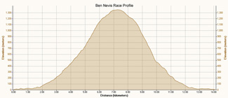
14km with 1360 metres of ascent
Results | Photos | More Photos
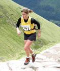
My 5th time at the Ben Nevis Race, and 2nd fastest time in 1:52:35, although 6½ minutes slower than last year, mainly due to being 5 minutes slower to the summit. Ellie managed 2:17:38 in her first attempt at the race, despite taking some nasty falls.


5 comments:
Congratulations on a great run Chris. Thanks too for posting the pictures - as usual they are excellent.
John
PS - what software do you use to show your routes and elevation? I've just bought a gramin 205 and am enjoying downloading info on to computer. Just cycle routes at the moment as my foot is sore!
Hi John,
Thanks for your comments. I was a little slower on the climb this year, but felt fairly strong on the descent.
For the route maps, I upload the Garmin 205 data to SportTracks, then export the track as GPX. Then rename the GPX file to an XML file and open it in Excel. I then convert in Excel the Lat/Long values into TXF track file format and paste the data into a Notepad file that I save with a TXF extension. I then import the TXF file to Memory Map as a track and highlight it and change the track colour. I then do a screen snapshot and paste the clipboard into Adobe Photoshop Elements and crop the image and Save for Web the image twice as 2 different image sizes for thumbnail and main image. I then drag the files onto my webspace using SmartFTP, so that I can use their URL in my blog posts.
For the elevation graphs I also use SportTracks, but copy and paste the clipboard to Photoshop Elements to add any text or annotation, before saving 2 different image sizes.
I gave you a shout at the start of the Glasgow Half on Sunday, but not sure if I got a photo of you.
Was it that the half marathon that caused the foot trouble?
Chris
Thanks Chris for the information about the software.
The memory map looks good but I might need to wait for a birthday!
I've used http://www.goodrunguide.co.uk/ and http://www.everytrail.com/ so far and they seem to work well.
I'm really impressed with the 205. I've only used it on my bike so far as my foot is still sore.
I saw the doctor today and he reckons it is just some inflamation on the joint of the toe so I should be able to start running again next week.
It was sore before the Glasgow half and I probably shouldn't have run but I thought it would be alright!
Thanks again
John
Chris - you do know you can import gpx files directly into MM5?
BTW - My 305 broke again and they've sent me a 405 as a replacement!
Derek - yes I know about MM5 and GPX - however I only have MM4 :-(
But converting GPX to TXF is pretty trivial since the file i just a list of lat/long values.
Nice one getting the 405! Perhaps I'll need to break my 205.
Post a Comment