
6 days hiking and jogging with Ellie in the Sierra de Grazalema and Sierra de las Nieves.
Day 1: Friday 21st March
Grazalema - Benaocaz circuit, 24km
Photos from Day 1


For our first day in Grazalema, we gathered our bearings with a straightforward circuit to the village of Benaocaz. The weather was fairly grey and dreary, so didn't show off the surrounds in their best light, and we carelessly missed out the detour to the Salto del Cabrero "goat herder's leap", which apparently was the highlight of the route.
Day 2: Saturday 22nd March
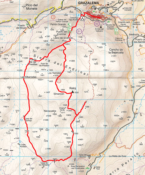
Grazalema to Reloj 1535m, 14km
Photos from Day 2


Day 2 started with a visit to the Mirador del Sagrado Corazon viewpoint overlooking the white-washed town of Grazalema. After passing the nearby ruin of Ermita del Calvario we headed straight up into the forest, following a faint trail of yellow arrows that lead to Cancho de la Bejeruela, from where we descended onto a wild scrubby plateau leading across to the imposing rocky mound of Reloj 1535m. There was no discernible path up the hill, so we headed straight up steep-angled rough limestone slabs, making reasonable progress until the weather suddenly turned nasty, with mist dropping and freezing cold gusty wind. After only the briefest visit to the trig pillar, we carefully descended as fast as we could to get the rough sharp limestone. The going was fairly tricky until we finally hit a proper trail that took us quickly down to the Tajo Rodillo campground, nestling below the massive rocky tower of Penon Grande.
Day 3: Sunday 23rd March
Grazalema to Simancon 1564m and Reloj 1535m, 20km
Photos from Day 3

After baling out of the Reloj - Simancon traverse yesterday, we decided to head back again, this time in the opposite direction, so starting up the trail behind Toja Rodillo campground, and heading up the trail towards Los Yedrales before turning left to ascend the barren rocky peak of Simancon 1564m, which had a reasonable smearing of snow and ice from yesterday afternoon's inclement weather. Today we had no problems in traversing the rock slabs to Reloj 1535m, and then descending the steep south ridge to well at Charca Verde. Here we bumped into three Spanish guys, who were the only people we saw all day on the hill. From here, instead of taking the short easy way back to Grazalema, we decided to continue south to join the trail past Caza de los Navazos, which despite the rather rough trackless descent took us into some fantastic scenery. Lush green valleys surrounded by rocky limestone peaks.
Day 4: Monday 24th March
Navazo Alto 1395m from Villaleunga del Rosario, 13km
Photos from Day 4

Since the hire car had been sitting from 3 days unused now, we decided to head round the hills to a new starting point at Villaluenga del Rosario - a grand name for a rather small strangely deserted pueblo blanca. Our initial attempts at gaining the south west ridge of Navazo Alto came to nothing, since despite trashing up the steep hillside through rocks and vegetation, we couldn't find any festige of track, so decided to bale out and hit the main road around to Benaocaz, which meant we were at least doing some running, and we also managed to briefly escape the road on a short section of the GR7 hiking trail. We took full advantage of the drinking fountains in Benaocaz before launching back uptowards Navazo Alto, this time from the north, but the hill looking equally impenetrable, with huge flanks of steep limestone crag. We ended up skirting the entire north side of the hill, until we picked up trail that double-back up the east ridge, and we finally made the summit having circumnavigated the entire hill to get there. The route off was very simple by comparison, as we dropped straight into the back of Villaluenga, with it's huge bullring clearly visible from above.
Day 5: Tuesday 25th March
Montejaque to Cortes de la Frontera, 44km
Photos from Day 5

Day 5 was by far our longest outing of the trip, starting from Montejaque, and taking just over 7 hours. We did however stop in Cortes de la Frontera for multiple ice creams before starting out on the return leg to Montejaque, getting frazzled in the strong afternoon sun.
Day 6: Wednesday 26th March
Torrecilla 1919m from Quejigales, 12km
Photos from Day 6


Our final day of the trip saw us switching ranges to bag Torrecilla 1919m, the highest peak in the Sierra de las Nieves, and in fact the highest hill in western Andalucia. The lower section of the route was a good trail in scenic, sheltered pine forest, but the upper section was exposed and barren. For the final 100m of ascent, the wind speed increased to the point where speech and standing upright were both almost impossible. Battered by a penetratingly cold wind, we only stayed on the summit for a maximum of 1 minute before getting virtually blown straight off back down the trail. The return journey to Quedrigales was pretty quick, with nice fast runnable descent through the forest. The whole outing taking about 3 hours.


2 comments:
Chris, 'speech and standing upright were both almost impossible. Battered by a penetratingly cold wind'. Just like home then (but a lot higher)!
Great blogg this Chris.krsob
Wow! Great trip. Makes Milton Keynes feel er well like Milton Keynes. ;-)
Post a Comment